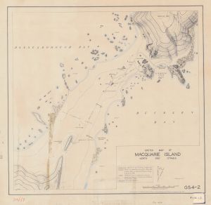
Map 14274: Sketch Map of Macquarie Island North End Isthmus
Map details
| Map Number | 14274 |
| Title | Sketch Map of Macquarie Island North End Isthmus |
| Edition | - |
| Scale | 1 : 2200 |
| Publication date | May 1949 |
| Publisher |
Bureau of Mineral Resources, Geology and Geophysics, Department of National Development, Canberra (Australia)
|
| Spatial coverage |
(158.9269° -54.4961°)
,
(158.9456° -54.4961°)
,
(158.9456° -54.5056°)
(158.9269° -54.5056°) |
| Projection | - |
| Physical size | 51 x 53.5 cm |
| Notes |
Reference: 158°57'E 54°37'S by E. Webb 1911. Control based on theodolite survey by L. Blake 1911 and a plane table survey around the base area by A. Bunbury 1949. Detail sketched in around control by controlled sketching from air and ground photos by K. Summons 1949. |
| Reference | G54-2 |
| Keywords | Webb , Blake , Bunbury , Summons , Geophysics , Station , Base , Survey Marks , Topographic |
Downloads
This is a hard copy map that has been scanned. See information about obtaining copies of hard copy maps.
- A print file (PDF) of the map's rear page
- A print file (PDF)
- A LZW compressed TIFF
- National Library of Australia Bib ID 4493307 (External site)
Map Lists
This map belongs to the following lists. Use the link on the list to see all maps belonging to that list
Additional Information
Preview