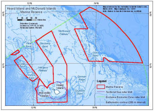
Map 14357: Heard Island and McDonald Islands Marine Reserve
Map details
| Map Number | 14357 |
| Title | Heard Island and McDonald Islands Marine Reserve |
| Edition | 3 |
| Scale | 1 : 3 800 000 |
| Publication date | March 2015 |
| Publisher |
Australian Antarctic Division (Australia)
|
| Spatial coverage |
( 70.3675° -49.7639°)
,
( 79.3156° -49.7639°)
,
( 79.3156° -53.6383°)
( 70.3675° -53.6383°) |
| Projection | Gnomonic |
| Physical size | 12.3 x 17.2 cm |
| Notes |
The map shows the Heard Island and McDonald Islands Marine Reserve boundary that came into effect in March 2014. The bathymetric contours and shading were derived from the bathymetric grid described by the Geoscience Australia metadata record 'Kerguelen Plateau Bathymetric Grid 2010'. Names in inverted commas are unofficial. These names denote where samples have been collected for Australian Antarctic Science Project 1189. They are not intended to denote geographic features. |
| Keywords | Coral , Aurora , Discovery , Shell , Pike , Gunnari |
Downloads
This is a digital map available for downloading.
Map Lists
This map belongs to the following lists. Use the link on the list to see all maps belonging to that list
Additional Information
| Horizontal datum | WGS84 |
Preview