Map 14565: Windmill Islands Bathymetry
Map details
| Map Number | 14565 |
| Title | Windmill Islands Bathymetry |
| Edition | 1 |
| Scale | 1 : 15 000 |
| Publication date | April 2017 |
| Publisher |
Australian Antarctic Division (Australia)
|
| Spatial coverage |
(110.3578° -66.2217°)
,
(110.5844° -66.2217°)
,
(110.5844° -66.3222°)
(110.3578° -66.3222°) |
| Projection | Universal Transverse Mercator |
| Physical size | 79 x 72 cm |
| Notes |
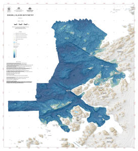
This map displays nearshore bathymetry at the Windmill Islands, Antarctica. The data is the result of a survey by the Royal Australian Navy in 2013/14 and a survey by Geoscience Australia and the Royal Australian Navy in 2014/15. |
| Keywords | Newcomb Bay , O'brien Bay , Bathymetry |
Downloads
This is a digital map available for downloading.
Map Lists
This map belongs to the following lists. Use the link on the list to see all maps belonging to that list
Additional Information
| Horizontal datum | WGS84 |
| Vertical datum | Mean sea level |
| Vertical unit | Metres |
| Nomenclature | Australian Antarctic Gazetteer |
Preview