Map 16006: Casey: Station Limits
Map details
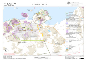
| Map Number | 16006 |
| Title | Casey: Station Limits |
| Edition | 9 |
| Previous edition | [Previous edition : 8] |
| Scale | 1 : 8600 |
| Publication date | September 2023 |
| Publisher |
Australian Antarctic Division (Australia)
|
| Spatial coverage |
(110.5078° -66.2764°)
,
(110.5444° -66.2764°)
,
(110.5444° -66.2853°)
(110.5078° -66.2853°) |
| Projection | Universal Transverse Mercator |
| Physical size | 21 x 29.7 cm A4 |
| Keywords | Budnick , Reeve , Boving , Nicholson , Crane , Geoffrey , Brown , Thala , ASPA 135 |
Downloads
This is a digital map available for downloading.
Map Lists
This map belongs to the following lists. Use the link on the list to see all maps belonging to that list
- Windmill Islands / Casey - extended list
- Tide gauge locations
- Classroom Antarctica
- Windmill Islands / Casey - core list
Additional Information
| Horizontal datum | WGS84 |
| Vertical datum | Mean sea level |
| Vertical unit | Metres |
| Nomenclature | Australian Antarctic Gazetteer |
Preview