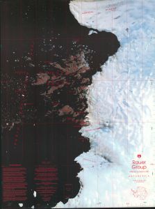
Map 47: Rauer Group / Princess Elizabeth Land
Map details
| Map Number | 47 |
| Title | Rauer Group / Princess Elizabeth Land |
| Edition | 1 |
| Scale | 1 : 50 000 |
| Publication date | June 1991 |
| Publisher |
Australian Antarctic Division (Australia)
|
| Spatial coverage |
( 77.4567° -68.6817°)
,
( 78.3283° -68.6817°)
,
( 78.3283° -69.0033°)
( 77.4567° -69.0033°) |
| Projection | Transverse Mercator |
| Physical size | 93 x 69 cm |
| Notes | This map was also published as a double-sided map. This entry in the map catalogue refers the satellite image map published in June 1991. Refer to Map 48 for the topographic map published in June 1992. |
| Reference | Cat.No:L14 in 'ANARE Catalogue of Maps and Hydrographic Charts 1997' |
| Keywords | Ingrid , Christensen , Sorsdal , Prydz , Lookout , Lunnyy , Slon , Filla , Efemova , Hop , Flag , Shleyf , Shcherbinina , Mather , Varyag , Lokot , Pchelka , Hyslop , Torckler , Sapozhok , Rybachij , Cjubuk , Drakon , Macey , Law , Browns , Peters , Chaos , Ranvik , Satellite Imagery |
Downloads
This is a hard copy map that has been scanned. See information about obtaining copies of hard copy maps.
Map Lists
This map belongs to the following lists. Use the link on the list to see all maps belonging to that list
- ANARE Catalogue of Maps and Hydrographic Charts 1997
- Rauer Group
- Satellite image maps
- Oziexplorer maps
Additional Information
| Horizontal datum | WGS84 |
| Magnetic variation | 76.6 degrees west in 1991 |
| Nomenclature | Australian Antarctic Gazetteer |
Preview