Map 13029: Heard Island - East : satellite image map
Map details
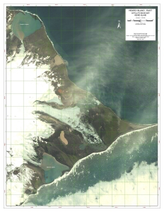
| Map Number | 13029 |
| Title | Heard Island - East : satellite image map |
| Edition | 1 |
| Scale | 1 : 20 000 |
| Publication date | October 2003 |
| Publisher |
Australian Antarctic Division (Australia)
|
| Spatial coverage |
( 73.6083° -53.0333°)
,
( 73.7861° -53.0333°)
,
( 73.7861° -53.1806°)
( 73.6083° -53.1806°) |
| Projection | Universal Transverse Mercator |
| Physical size | 83 x 62 cm |
| Notes | DigitalGlobe multispectral image. Image acquired 17 January 2003 with approximately 15% cloud cover. |
| Keywords | Heard Island , Spit Bay , Winston Lagoon , Compton Lagoon , Stephenson Lagoon , Satellite Imagery |
Downloads
This is a digital map available for downloading.
Map Lists
This map belongs to the following lists. Use the link on the list to see all maps belonging to that list
Additional Information
| Horizontal datum | WGS84 |
| Nomenclature | Australian Antarctic Gazetteer |
Preview