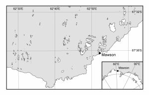
Map 13155: Holme Bay with Antarctic inset [Black and white]
Map details
| Map Number | 13155 |
| Title | Holme Bay with Antarctic inset [Black and white] |
| Edition | 1 |
| Scale | 1 : 261 300 |
| Publication date | June 2005 |
| Publisher |
Australian Antarctic Division (Australia)
|
| Spatial coverage |
( 62.4167° -67.5167°)
,
( 63.1667° -67.5167°)
,
( 63.1667° -67.6667°)
( 62.4167° -67.6667°) |
| Projection | Universal Transverse Mercator |
| Physical size | 6 x 10 cm |
| Keywords | Holme Bay , Mawson Station |
Downloads
This is a digital map available for downloading.
Map Lists
This map belongs to the following lists. Use the link on the list to see all maps belonging to that list
- Framne Mountains / Holme Bay / Mawson - extended list
- Black and white maps for publications
- Classroom Antarctica
Additional Information
| Horizontal datum | WGS84 |
Preview