Map 13159: McDonald Islands Satellite Image Map
Map details
| Map Number | 13159 |
| Title | McDonald Islands Satellite Image Map |
| Edition | 1 |
| Scale | 1 : 7500 |
| Publication date | August 2005 |
| Publisher |
Australian Antarctic Division (Australia)
|
| Spatial coverage |
( 72.1000° -52.5406°)
,
( 73.1000° -52.5406°)
,
( 73.1000° -53.5406°)
( 72.1000° -53.5406°) |
| Projection | Universal Transverse Mercator |
| Physical size | 63 x 83 cm |
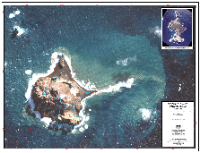
| Notes |
Image acquired 9 April 2003 with less than 5% cloud cover. Digital Globe Pan Sharpened Image, georeferenced from the Satellite Ephemeris data. The map includes an aerial photograph of McDonald Islands taken on March 11, 1980 as an inset. The satellite image is overlaid with the coastline mapped from 1980 aerial photography. |
| Keywords | Satellite Imagery |
Downloads
This is a digital map available for downloading.
Map Lists
This map belongs to the following lists. Use the link on the list to see all maps belonging to that list
Additional Information
Preview