Map 13275: Heard Island - East : satellite image map
Heard Island January 2006
Map details
| Map Number | 13275 |
| Title | Heard Island - East : satellite image map Heard Island January 2006 |
| Edition | 1 |
| Scale | 1 : 20 000 |
| Publication date | May 2006 |
| Publisher | - |
| Spatial coverage |
( 73.6083° -53.0333°)
,
( 73.7861° -53.0333°)
,
( 73.7861° -53.1806°)
( 73.6083° -53.1806°) |
| Projection | Universal Transverse Mercator |
| Physical size | 83 x 62 cm |
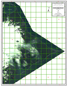
| Notes |
Digital Globe Multi Spectral Image. Image acquired 30 January 2006. This image is dark and couldn't be enhanced more in the image processing software. A copy of the image linked from this page was enhanced in a graphics package. It highlights the vegetation well. |
| Keywords | Heard Island , Spit Bay , Winston Lagoon , Compton Lagoon , Stephenson Lagoon , Satellite Imagery |
Downloads
This is a digital map available for downloading.
Map Lists
This map belongs to the following lists. Use the link on the list to see all maps belonging to that list
Additional Information
| Horizontal datum | WGS84 |
| Nomenclature | Australian Antarctic Gazetteer |
Preview