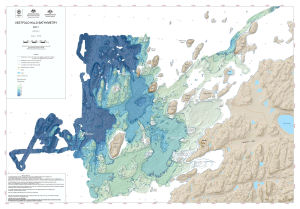
Map 14278: Vestfold Hills Bathymetry
Map 1
Map details
| Map Number | 14278 |
| Title | Vestfold Hills Bathymetry Map 1 |
| Edition | 1 |
| Scale | 1 : 15 000 |
| Publication date | May 2014 |
| Publisher |
Australian Antarctic Division (Australia)
|
| Spatial coverage |
( 77.7442° -68.5206°)
,
( 78.0683° -68.5206°)
,
( 78.0683° -68.6014°)
( 77.7442° -68.6014°) |
| Projection | Universal Transverse Mercator |
| Physical size | 64.3 x 92.2 cm |
| Notes |
This map displays nearshore bathymetry at the Vestfold Hills, Antarctica. The data is the result of a February-March 2010 survey which was a collaborative project between Geoscience Australia, the Australian Hydrographic Service and the Australian Antarctic Division. |
| Keywords | Oldroyd Island , Waterhouse Island , Lugg Island , Plough Island , Lake Island , Boyd Island , Magnetic Island , Turner Island , Thala Rock , Barratt Island , Bluff Island , Trigwell Island , Flutter Island , Anchorage Island , Krat Rocks , Hobby Rocks , O'gorman Rocks , Anchorage Patch , Gardner Island , Keuken Island , Newman Shoal , Torckler Rocks , Heidemann Valley , Heidemann Bay , Davis , Bathymetry |
Downloads
This is a digital map available for downloading.
Map Lists
This map belongs to the following lists. Use the link on the list to see all maps belonging to that list
Additional Information
| Horizontal datum | WGS84 |
| Vertical datum | Mean sea level |
| Nomenclature | Australian Antarctic Gazetteer |
Preview