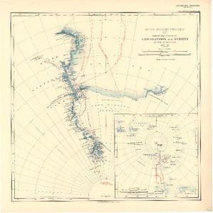
Map 3688: British Antarctic Expedition 1907 : General Map showing the Explorations and Surveys of the Expedition 1907-09.
Map details
| Map Number | 3688 |
| Title | British Antarctic Expedition 1907 : General Map showing the Explorations and Surveys of the Expedition 1907-09. |
| Edition | - |
| Scale | 1 : 6 000 000 |
| Publication date | 1909 |
| Publisher |
Royal Geographical Society (United Kingdom)
|
| Spatial coverage |
(-135.0000° -68.0000°)
,
( 90.0000° -68.0000°)
,
( 90.0000° -90.0000°)
(-135.0000° -90.0000°) |
| Projection | Not Given |
| Physical size | 44.5 x 44.5 cm |
| Notes | Includes inset of ship's tracks from New Zealand (1:48,000,000) |
| Reference | 974 |
| Keywords | British Antarctic Expedition 1907-1909 , Shackleton , "Nimrod" , Ship Tracks , Historical |
Downloads
Map Lists
This map belongs to the following lists. Use the link on the list to see all maps belonging to that list
Additional Information
Preview