Vestfold Hills / Davis - extended list
View All Map ListsAn extended list of maps of the Vestfold Hills including maps of Davis.
Showing 21 to 40 of 48 maps. On page 2 of 3, go to the Previous Page or Next Page
Distribution of Weddell seal breeding colonies at the Vestfold Hills View Map Details
Map ID - 13289
Published On - July-2000 Scale - 1 : 238 000 Physical Size- - 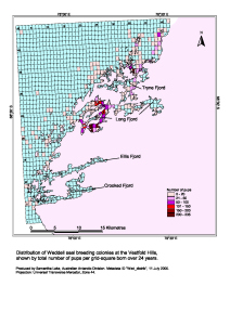
|
Geology of the Northern Vestfold Hills, East Antarctica View Map Details
Map ID - 12717
Published On - May-2001 Scale - 1 : 30 000 Physical Size- 85 x 110 cm 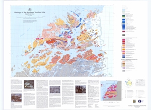
|
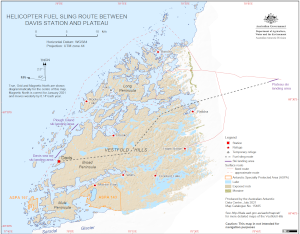
Helicopter Fuel Sling Route Between
|
Ionosonde at Davis Station, Antarctica View Map Details
Map ID - 13205
Published On - November-2005 Scale - 1 : 1400 Physical Size- - 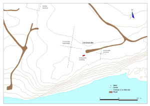
|
Location of Davis View Map Details
Map ID - 14359
Published On - March-2015 Scale - 1 : 26 000 000 Physical Size- 21 x 29.7 cm A4 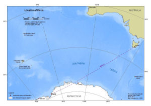
|
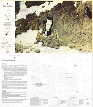
Marine Plain : Satellite image map, Vestfold Hills View Map Details
Map ID - 13048
Published On - October-2003 Scale - 1 : 20 000 Physical Size- 61.5 x 67 cm 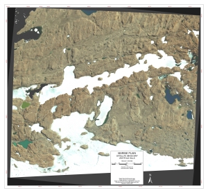
|
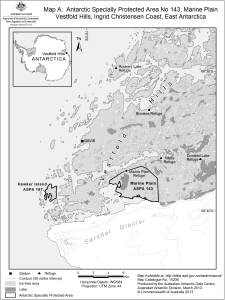
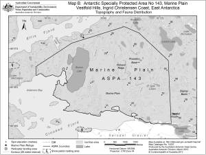
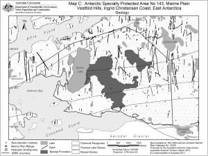
Marine Plain, Vestfold Hills, Ingrid Christensen Coast, East Antarctica
|
Marine Plain, Vestfold Hills, Ingrid Christensen Coast, East Antarctica
|
Marine Plain, Vestfold Hills, Ingrid Christensen Coast, East Antarctica
|
MFSA radar at Davis Station, Antarctica View Map Details
Map ID - 13204
Published On - November-2005 Scale - 1 : 1400 Physical Size- - 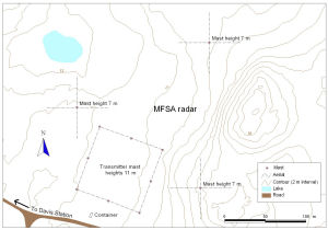
|
Site of Special Scientific Interest No. 25
|
Southern Vestfold Hills [Black and white] View Map Details
Map ID - 13737
Published On - November-2009 Scale - 1 : 280 000 Physical Size- 8 x 8.9 cm ![Southern Vestfold Hills [Black and white]](/database/mapcat/vestfold/vestfold_hills_south_bw_13737_thumb.jpg)
|
Vestfold Hills View Map Details
Map ID - 12890
Published On - October-2001 Scale - 1 : 50 000 Physical Size- 98 x 69 cm 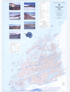
|
Vestfold Hills View Map Details
Map ID - 16016
Published On - August-2024 Scale - 1 : 50 000 Physical Size- 82.8 x 117.7 cm A0 
|
Vestfold Hills : Map 1 of 5 View Map Details
Map ID - 16017
Published On - August-2024 Scale - 1 : 50 000 Physical Size- 29.7 x 42 cm A3 Vertical Unit - Meters 
|
Vestfold Hills : Map 2 of 5 View Map Details
Map ID - 16018
Published On - August-2024 Scale - 1 : 50 000 Physical Size- 29.7 x 42 cm A3 Vertical Unit - Meters 
|
Vestfold Hills : Map 3 of 5 View Map Details
Map ID - 16019
Published On - August-2024 Scale - 1 : 50 000 Physical Size- 29.7 x 42 cm A3 
|
Vestfold Hills : Map 4 of 5 View Map Details
Map ID - 16020
Published On - August-2024 Scale - 1 : 50 000 Physical Size- 29.7 x 42 cm A3 Vertical Unit - Meters 
|
Vestfold Hills : Map 5 of 5 View Map Details
Map ID - 16021
Published On - August-2024 Scale - 1 : 50 000 Physical Size- 29.7 x 42 cm A3 Vertical Unit - Meters 
|
Vestfold Hills [Black and white] View Map Details
Map ID - 13142
Published On - May-2005 Scale - 1 : 421 813 Physical Size- 9.2 x 7.5 cm ![Vestfold Hills [Black and white]](/database/mapcat/vestfold/vestfold_hills_bw_thumb.jpg)
|
Showing 21 to 40 of 48 maps. On page 2 of 3, go to the Previous Page or Next Page