Antarctic Maps
Large scale maps covering scales below 1:100 000
-
that cover
| 65° 00' 00.0" S to 70° 00' 00.0" S |
| 78° 00' 00.0" W to 57° 00' 00.0" W |
For additional maps, see the Mapping for the Map Catalogue.
Use the link on the Map No or the preview if it exists to see full details.
| Map No | Map Title | Year | Scale | Preview |
|---|---|---|---|---|
| 5869 | Adelaide Anchorage | 1984 | 1 : 30 000 | |
| 361 | Adelaide Island : Southwestern approaches | 1995 | 1 : 75 000 | |
| 5512 | Adelaide Island : Southwestern approaches | 1983 | 1 : 75 000 | |
| 14427 | Approaches to Adelaide, Graham Land | 1983 | 1 : c56 500 | |
| 5807 | Approaches to Arthur Harbour | 1978 | 1 : 50 000 | |
| 5872 | Approaches to Prospect Point | 1984 | 1 : 50 000 | |
| 5867 | Argentine Islands | 1984 | 1 : 15 000 | |
| 14377 | Argentine Islands, Graham Land | 1996 | 1 : c26 000 | |
| 12823 | Base General San Martin Baie Marguerite Luftbildkarte |
1999 | 1 : 50 000 | |
| 5027 | Biscoe Islands | 1964 | 1 : 30 000 | |
| 14398 | Booth Island area, Graham Land | 1959 | 1 : 28 000 | |
| 14423 | Bragg Islands, Crystal Sound, Graham Land | 1960 | 1 : c12 000 | |
| 5504 | British Antarctic Survey Base: Rothera, Marguerite Bay | 1983 | 1 : 25 000 | |
| 5690 | British Antarctic Territory, Argentine Islands with Anagram Islands | 1964 | 1 : 10 000 | |
| 3234 | British Antarctic Territory-Adelaide-Rothera Point | 1980 | 1 : 25 000 | |
| 3385 | Camp Point to Red Rock Ridge / Graham Land | 1971 | 1 : 50 000 | |
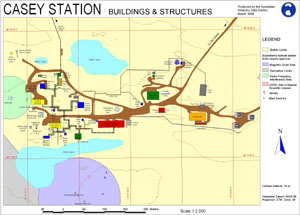
| 10325 | Casey Station Buildings and Structures | 1998 | 1 : 2000 |
 |
| 14380 | Dion Islands, Marguerite Bay, Graham Land | 1959 | 1 : 10 000 | |
| 14382 | Easternmost of the Henkes Islets off the south coast of Adelaide Island | 1955 | 1 : 10 000 | |
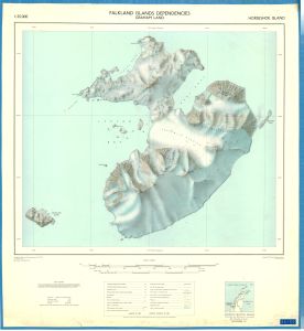
| 5696 | Falkland Islands Dependencies, Graham Land : Horsehoe Island | 1960 | 1 : 25 000 |
 |
| 14385 | Faure Islets, Marguerite Bay, Graham Land | 1955 | 1 : 50 000 | |
| 8434 | Fig. 3. Geological sketch map of Horseshoe and Lagotellerie Islands | 1983 | 1 : 25 000 | |
| 5806 | Flandres Bay and Approaches | 1967 | 1 : 50 000 | |
| 8360 | Geomorphology of the Ablation Point massif, Alexander Island | 1983 | 1 : 50 000 | |
| 5581 | Graham Coast: Approaches to Prospect Point | 1973 | 1 : 50 000 | |
| 5579 | Graham Coast: Argentine Islands | 1973 | 1 : 15 000 | |
| 3354 | Graham Land | 1994 | 1 : 25 000 | |
| 14405 | Horseshoe Island, Marguerite Bay, Graham Land | 1959 | 1 : 25 000 | |
| 5873 | Lystad Bay | 1984 | 1 : 50 000 | |
| 5503 | Marguerite Bay: Debenham Islands | 1 : 25 000 | ||
| 5510 | Marguerite Bay: Neny Island | 1 : 50 000 | ||
| 14402 | Martin Islands, Biscoe Islands, West Graham Land | 1957 | 1 : 20 000 | |
| 5871 | Nevy Island | 1984 | 1 : 50 000 | |
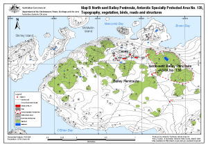
| 13512 | North-east Bailey Peninsula, Antarctic Specially Protected Area No. 135 : Topography, vegetation, birds, roads and structures (Map B) | 2008 | 1 : 12 000 |
 |
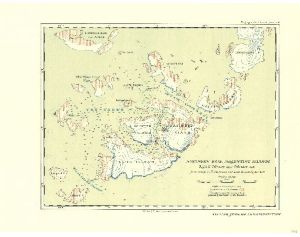
| 3712 | Northern Base, Argentine Islands : British Graham Land Expedition. February 1935 - February 1936 | 1938 | 1 : 15 000 |
 |
| 14399 | Petermann Island area, Graham Land | 1959 | 1 : 8130 | |
| 2095 | Puertos en el Territorio Antartico Chileno: Bahia Neny | 1947 | 1 : 20 000 | |
| 3388 | Rothera Point - Wright Peninsula, Adelaide Island Wright Peninsula |
1995 | 1 : 50 000 | |
| 14437 | Rothera Point, Adelaide Island, Graham Land | 1994 | 1 : 25 000 | |
| 3387 | Rothera Point-Wright Peninsula, Adelaide Island Rothera Point |
1995 | 1 : 2000 | |
| 14373 | Soundings in area of Stonington Island | 1947 | 1 : 2000 | |
| 14383 | Stonington Island area, Marguerite Bay, Graham Land | 1973 | 1 : 50 000 | |
| 14379 | Stonington Island, Marguerite Bay, Graham Land | 1964 | 1 : 2000 | |
| 14384 | Terra Firma Islands, Marguerite Bay, Graham Land | 1959 | 1 : 15 840 |