Antarctic Maps
Large scale maps covering scales below 1:100 000
-
that cover
| 72° 00' 00.0" S to 84° 00' 00.0" S |
| 120° 00' 00.0" W to 60° 00' 00.0" W |
For additional maps, see the Mapping for the Map Catalogue.
Use the link on the Map No or the preview if it exists to see full details.
| Map No | Map Title | Year | Scale | Preview |
|---|---|---|---|---|
| 13228 | Coal Nunatak, Alexander Island | 2005 | 1 : 10 000 | |
| 13226 | Corner Cliffs / Citadel Bastion | 2005 | 1 : 25 000 | |
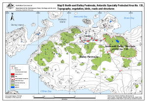
| 13512 | North-east Bailey Peninsula, Antarctic Specially Protected Area No. 135 : Topography, vegetation, birds, roads and structures (Map B) | 2008 | 1 : 12 000 |
 |
| 13400 | Patriot Hills blue ice area, Antarctica | 2006 | 1 : 10 000 | |
| 13451 | Vinson Massif and the Sentinel Range, Ellsworth Mountains | 2007 | 1 : 50 000 | |
| 13346 | Vinson Massif and the Sentinel Range, Ellsworth Mountains | 2006 | 1 : 50 000 |