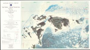
Map 5111: Taylor Rookery, Specially Protected Area No.1, Orthophoto Map
Map details
| Map Number | 5111 |
| Title | Taylor Rookery, Specially Protected Area No.1, Orthophoto Map |
| Edition | 1 |
| Scale | 1 : 5000 |
| Publication date | September 1998 |
| Publisher |
Australian Antarctic Division (Australia)
|
| Spatial coverage |
( 60.8700° -67.4400°)
,
( 60.9010° -67.4400°)
,
( 60.9010° -67.4590°)
( 60.8700° -67.4590°) |
| Projection | Universal Transverse Mercator |
| Physical size | 36 x 66 cm |
| Notes |
The orthophoto is compiled from aerial phtography flown in January 1997 with a Zeiss UMK 1318 camera (format 160mm X 120mm). The map features 10 metre interval contours. A copy of this map in the form of a TIF file is available upon request from the Australian Antarctic Data Centre. The file is 266 Mb. |
| Reference | L11 |
| Keywords | Emperor Penguin , Orthophoto , Spa , Taylor Rookery , Satellite Imagery |
Downloads
Map Lists
This map belongs to the following lists. Use the link on the list to see all maps belonging to that list
- Taylor Rookery
- Orthophoto maps
- Antarctic Specially Protected Areas and Antarctic Specially Managed Areas maps
Additional Information
| Horizontal datum | WGS84 |
| Vertical datum | Mean sea level |
| Magnetic variation | Magnetic North is 63.4 degrees west of True North |
| Nomenclature | Australian Antarctic Names Gazetteer |
Preview