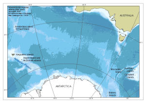
Map 13576: Heard Island and McDonald Islands in relation to Australia and Antarctica
Map details
| Map Number | 13576 |
| Title | Heard Island and McDonald Islands in relation to Australia and Antarctica |
| Edition | 1 |
| Scale | 1 : 37 000 000 |
| Publication date | December 2008 |
| Publisher |
Australian Antarctic Division (Australia)
|
| Spatial coverage |
( 50.0000° -33.0000°)
,
(180.0000° -33.0000°)
,
(180.0000° -70.0000°)
( 50.0000° -70.0000°) |
| Projection | Azimuthal Equidistant |
| Physical size | 14.8 x 21 cm |
| Notes |
This map is published in: Hibberd, T. & Moore, K. 2009. Field identification guide to Heard Island and McDonald Islands benthic invertebrates: a guide for scientific observers aboard fishing vessels. Australian Antarctic Division, Kingston, Tasmania. The bathymetric data is from "Centenary Edition of the GEBCO Digital Atlas", 2003, published on behalf of the Intergovernmental Oceanographic Commission and the International Hydrographic Organization as part of the General Bathymetric Chart of the Oceans; British Oceanographic Data Centre, Liverpool. The Antarctic coastline data is from the Antarctic Digital Database version 5 © Scientific Committee on Antarctic Research 1993-2006. |
| Keywords | Amsterdam , St Paul , Kerguelen , Macquarie , Auckland , Campbell , Balleny , Topographic |
Downloads
This is a digital map available for downloading.
Map Lists
This map belongs to the following lists. Use the link on the list to see all maps belonging to that list
Additional Information
| Horizontal datum | WGS84 |
Preview