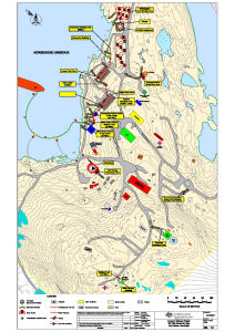
Map 14454: Annex B: Mawson Station Spill Risk Assessment Map
Land and Marine-Based Spills
Map details
| Map Number | 14454 |
| Title | Annex B: Mawson Station Spill Risk Assessment Map Land and Marine-Based Spills |
| Edition | 4 |
| Previous edition | [Previous edition : 3] |
| Scale | 1 : 1000 |
| Publication date | 01 July 2014 |
| Publisher |
Australian Antarctic Division (Australia)
|
| Spatial coverage |
( 62.8681° -67.5994°)
,
( 62.8792° -67.5994°)
,
( 62.8792° -67.6056°)
( 62.8681° -67.6056°) |
| Projection | Universal Transverse Mercator |
| Physical size | 59.4 x 42 cm A2 |
| Notes | Map published in the Australian Antarctic Division fuel spill contingency plans. |
| Reference | M/08/02 |
| Keywords | Spill Risk , Drum Farm , Fixed Fuel Pipeline , Underground Fuel Line , Oil Spill Equipment |
Downloads
This is a digital map available for downloading.
Map Lists
This map belongs to the following lists. Use the link on the list to see all maps belonging to that list
- Fuel Spill Contingency Plan maps
- Asset Management maps
- Framne Mountains / Holme Bay / Mawson - extended list
Additional Information
Preview