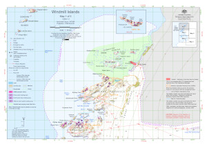
Map 16007: Windmill Islands : Map 1 of 5
Map details
| Map Number | 16007 |
| Title | Windmill Islands : Map 1 of 5 |
| Edition | 12 |
| Previous edition | [Previous edition : 11] |
| Scale | 1 : 50 000 |
| Publication date | September 2023 |
| Publisher |
Australian Antarctic Division (Australia)
|
| Spatial coverage |
(110.3681° -66.1739°)
,
(110.6722° -66.1739°)
,
(110.6722° -66.2972°)
(110.3681° -66.2972°) |
| Projection | Universal Transverse Mercator |
| Physical size | 29.7 x 42 cm A3 |
| Notes | Inset: Frazier Islands (ASPA 160) |
| Keywords | Waypoints , Clark Peninsula , Bailey Peninsula , Swain Group , ASPA 135 , ASPA 136 , ASPA 160 , Frazier Islands , Honkala Island , Burnett Island , Shirley Island , Donovan Islands , Jack's Donga , Wilkes Hilton , Berkley Island , Station Operational Area , Casey Ski Landing Area , Sea Ice Travel Boundary , Topographic |
Downloads
This is a digital map available for downloading.
Map Lists
This map belongs to the following lists. Use the link on the list to see all maps belonging to that list
Additional Information
| Horizontal datum | WGS 84 |
| Vertical datum | Mean sea level |
| Vertical unit | Metres |
| Magnetic variation | Magnetic North is 102 degrees west of True North |
| Nomenclature | Australian Antarctic Gazetteer |
Preview